NaturPanorama.ch - SwissPanoTour
Virtual and interactive panoramic trip through Swiss alps and Switzerland
Starting SwissPanoTour HTML5-Version...
For Mac, Windows and tablets.
For Android tablets, we recommend the following browsers: Current versions of Chrome or Android default browser.
How does SwissPanoTour work?
SwissPanoTour is an interactive panoramic tour through the Swiss Alps and Switzerland. From every admission place exist view contact with at least one other admission place. PanoTour allows you to jump by mouse click from one admission place to another. In this manner you can explore the Swiss Alps and Switzerland.
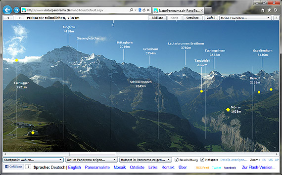
Yellow circles =

the admission places which are visible from the topical location directly.
Yellow rhomb =

link to external websites (municipality, mountain railway, tourism, SAC hut, etc.).
Which areas can be explored?
At the moment, panoramic pictures from the following regions of Switzerland including the Swiss Alps:
- The Bernese Oberland and the Bernese Alps
- The Emmental
- The Glarus and the Glarner Alps
- The Innerschweiz and the Urner Alps
- The Jura
- The Middle country
- The Ticino and the ticino Alps
- The Valais and the Valais Alps
- The Western Switzerland
- The Central Switzerland, incl. Schwyz (central Swiss Alps and Schwyzer Alps)
Who develops/operates SwissPanoTour and who is the photographer of the panoramas?
SwissPanoTour is developed and operated by the Company
Oberli Engineering GmbH.
All panoramic images were captured, assembled and labeled by
Simon Oberli, Hasle-Rüegsau, Switzerland.
What is the scope SwissPanoTour?
Main features of SwissPanoTour:
Number of panoramic photos: 502
Number of hotspots (yellow circles): 5948
Number of labeled peaks, lakes, towns, etc.: 14862
Number of links to external websites: 285
Date: 11.8.2014